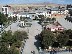
Yauri District
Appearance
Yauri
Kiskachay | |
|---|---|
 | |
 | |
| Country | |
| Region | Cusco |
| Province | Espinar |
| Capital | Yauri |
| Government | |
| • Mayor | Lindley Alfredo Salinas Perez |
| Area | |
| • Total | 747.78 km2 (288.72 sq mi) |
| Elevation | 3,915 m (12,844 ft) |
| Population | |
| • Total | 32,471 |
| • Density | 43/km2 (110/sq mi) |
| Time zone | UTC-5 (PET) |
| UBIGEO | 080801 |
Yauri District, also known as Espinar or Kiskachay District, is one of eight districts of the Espinar Province in Peru.[1] Its seat is Yauri (Yawri).
Geography
[edit]One of the highest peaks of the district is Chuqi Pirwa at approximately 4,800 m (15,700 ft). Other mountains are listed below:[2]
- Chuku Chuku
- Chuwa Chuwa
- Ch'iyar Jaqhi
- Hatun Quymi
- Huch'uy Quymi
- Janq'u
- Kimsa Chata
- Kiska Qhata
- Llallawa
- Pallana
- Pawkara
- Puka Nasa
- Qaqa Punku
- Q'illu Q'illu
- Thutayuq
- Urquyuq
- Wila Wila
- Wiska Apachita
- Yuraq Sunquyuq
Climate
[edit]| Climate data for Yauri, elevation 3,920 m (12,860 ft), (1991–2020) | |||||||||||||
|---|---|---|---|---|---|---|---|---|---|---|---|---|---|
| Month | Jan | Feb | Mar | Apr | May | Jun | Jul | Aug | Sep | Oct | Nov | Dec | Year |
| Mean daily maximum °C (°F) | 16.8 (62.2) |
16.5 (61.7) |
16.6 (61.9) |
16.5 (61.7) |
16.4 (61.5) |
16.0 (60.8) |
15.9 (60.6) |
17.0 (62.6) |
18.3 (64.9) |
18.9 (66.0) |
19.5 (67.1) |
18.2 (64.8) |
17.2 (63.0) |
| Mean daily minimum °C (°F) | 3.5 (38.3) |
3.7 (38.7) |
3.2 (37.8) |
0.9 (33.6) |
−4.7 (23.5) |
−8.6 (16.5) |
−8.8 (16.2) |
−6.9 (19.6) |
−3.5 (25.7) |
−0.8 (30.6) |
0.2 (32.4) |
2.1 (35.8) |
−1.6 (29.1) |
| Average precipitation mm (inches) | 177.4 (6.98) |
178.8 (7.04) |
134.9 (5.31) |
61.5 (2.42) |
8.4 (0.33) |
1.9 (0.07) |
2.8 (0.11) |
9.1 (0.36) |
15.5 (0.61) |
45.6 (1.80) |
57.1 (2.25) |
128.0 (5.04) |
821 (32.32) |
| Source: National Meteorology and Hydrology Service of Peru[3] | |||||||||||||
See also
[edit]References
[edit]- ^ (in Spanish) Instituto Nacional de Estadística e Informática. Banco de Información Distrital Archived April 23, 2008, at the Wayback Machine. Retrieved April 11, 2008.
- ^ escale.minedu.gob.pe/ UGEL map Espinar Province (Cusco Region)
- ^ "Normales Climaticás Estándares y Medias 1991-2020". National Meteorology and Hydrology Service of Peru. Archived from the original on 21 August 2023. Retrieved 25 October 2023.
